JMap Mobile applications are replaced by JMap Survey.
The steps to deploy JMap Web and JMap Mobile applications are very similar. See the JMap Web Applications section for more information on the general process for JMap Mobile deployment. The options that are specific to JMap Mobile are described in this section.
JMap Mobile has been specifically designed to collect data in the field. Using a device's GPS and camera as well as the forms defined in JMap Admin, users can easily conduct inventories or inspections. Another feature of JMap Mobile is that it allows users to work without a network connection.
Editable data on JMap Mobile
Layers of points are the only type of data that can be edited (created, modified, deleted) by JMap Mobile. As configured in the JMap project, these layers must be editable and have several forms to enter attributes. In addition, JMap Mobile users must have the required editing permissions on these layers.
When JMap Mobile is deployed by the JMap administrator, the administrator must clearly indicate which layers will be editable by JMap Mobile. Thus, for each editable layer, the administrator creates a special type of layer called a JMap Overlay vector. These special layers allow you to load all of the layer's data in JMap Mobile, in the form of vectors with a table of attributes. This allows you to modify the data locally.
When a network connection becomes available, the changes made to the data in JMap Mobile are immediately sent to JMap Server.
Offline mode
Offline mode allows users to work with JMap Mobile when no network connection is available. In offline mode, the user can continue to view the map and work with editable data. All transactions conducted in offline mode are recorded on the device and sent to JMap Server when a connection (cellular or Wi-Fi) becomes available.
Working in offline mode requires some preparation on behalf of the JMap administrator. In order for the map to be available in offline mode, the layers must be tiled and cached. The levels that are to be available in offline mode must also be selected. Once these settings have been configured, the cache for the offline mode must be generated.
Refer to the section Using a GeoWebCache Server for more information on producing a tile cache and a cache for offline mode.
The following settings are specific to JMap Mobile.
Application options |
|
Track devices |
Activate this option in order for JMap Mobile applications to continuously send their geographic position to JMap Server. This option allows you to track the movement of mobile devices in real time when the JMap Mobile application is running. Note that this requires installing JMap's Tracking extension on the server. |
Configuring layers
Configuring layers for JMap Mobile is done almost the same way as for JMap Web. See the JMap Web Applications section for more information on configuring layers. JMap Overlay vectors are specific to JMap Mobile.
Layers |
|
JMap Overlay vector |
Create a dynamic layer that will be loaded on mobile applications in the form of vector data. Only points layers that exist in the selected JMap project can be used for this type of layer. If the user of the mobile application has the required permissions, that person can edit the data of this layer in the JMap Mobile application. |
When configuring layers, the offline option allows you to select the layers that will be available in offline mode. Only static, tiled, and cached layers can be selected.
Choosing levels for offline mode
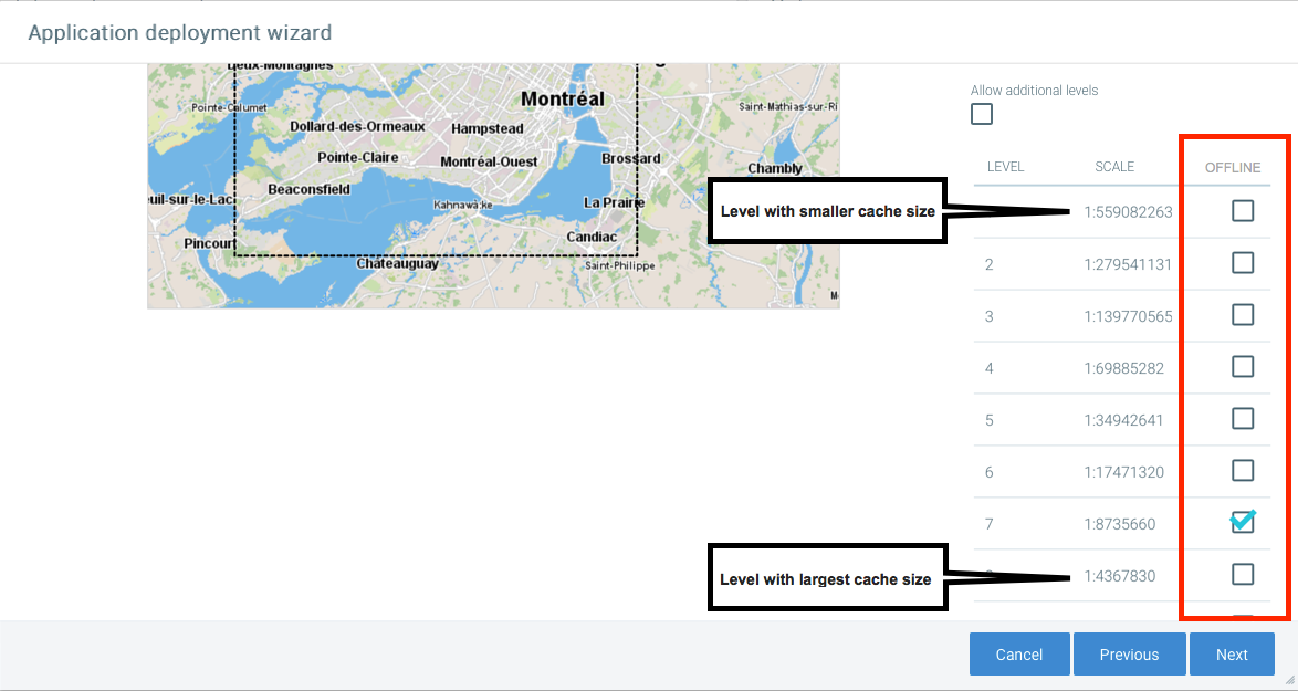
In order to limit the size of the cache for offline mode, you must select the levels that will be available offline. This is configured in the Geographic properties window of the JMap Mobile deployment wizard.

It is recommended to avoid selecting the highest levels (large scale, containing a lot of detail on a small portion of territory) because they are often too large. All the tiles of the layers for which the offline option is selected will be included in the offline cache for these levels.
Refer to the Using a GeoWebCache Server section for more information.