Style
The style of a layer determines the graphical representation of its spatial elements of the map. For example, the style of a line is determined by its thickness, color, dash pattern, etc. In JMap, each layer can have multiple styles. Only one style is visible at a time, depending on the scale of the displayed map.
Different styles can be configured for different scales. For example, a layer can have one unique style for all scales while another layer can have one style for scales greater than 1:20000 and another style for scales smaller than or equal to 1:20000.
Layers also have selection styles (one per style). These styles are used to display selected elements at different scales. The selection styles are generated automatically from the layer styles but they can be customized for each layer.
The presence of thematics on a layer will override the layer styles. When a thematic is active on a layer, the style of each element is determined by the value of its attributes and the thematic parameters. See Creating Thematics for more information.
Managing layer styles
You can define one or more styles for a layer. If there are many styles, each one will be used within a certain range of scales. By default, one style exists for each layer and it covers the full possible scale range. To manage the styles of a layer, press Style from the layer settings menu.
To add a new style, press Add. In the style configuration interface, you must define the maximum scale from which the new style will be used. Its minimum scale will be automatically be set to infinity or to the maximum scale of the next style.
To remove a style, select it from the list and press Remove. Note that the greater scale style cannot be deleted. When deleting styles, the remaining styles will be adjusted to cover the full possible scale range.
Once you have configured one or more styles, you can click on Create template (located to the right of each style) to create a new style template from one of the layer's styles. The style template will automatically be linked to the layer. See Style Templates for more information.
Creating/Modifying a style
You have the option to use an existing style template or to configure your own style. If you want to use a style template, click on Use a style template.... You will then choose to refer to it or to copy it.
If no style template is used, you need to configure the parameters that will define the style. Style configuration interfaces are different depending on the type of element (points, lines, polygons, text, etc.). Some style parameters are common to many element types but some are specific to certain types.
Antialiasing is a method of representing perfect, continuous vectors on imperfect, discontinuous display devices so that they look as perfect as possible. In every style configuration section in JMap Admin, you can enable antialiasing. This will result in better looking maps. However, display performances are reduced when antialiasing is enabled so use it judiciously.
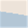
Example of polygon border without antialiasing (left) and with antialiasing (right)
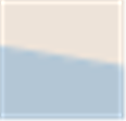
Partial object transparency can be used for every type of map element. A map element with a transparency value of 0% will be completely opaque while one with a 100% value will be invisible.
![]()
![]()
Example of polygon with 50% (left) and 10% (right) transparency
Styles for points
Style parameters for points |
|
Symbol |
Select the symbol to use for representing the elements. The symbol can be a vector symbol or an image. Vector symbols are provided with JMap and offer special characteristics compared to images. They can be resized without distortion and their border and fill color can be modified. However, they cannot be customized easily. Images are provided by the administrator and thus can be easily customized. However, their quality will be decreased if they are resized, unless you use SVG images. To provide your own images, place them in the following directory: JMAP_HOME/jmapadmin/icons Supported image formats are svg, gif, png and jpeg. If subdirectories are created, they will be seen when browsing the image directory. This allows you to organize your image library. |
Size |
Specify the size of the symbol. A value of 1 corresponds to the original size of the symbol or image. |
Proportional size |
Select this option if you want the size of the displayed symbols to vary in proportion with the map scale. You must enter the reference scale that will display the normal size of the symbols. |
Use antialiasing |
Select this option to activate antialiasing. |
Transparency |
Specify the partial transparency of the symbol. |
Offsetted symbol by X/Y |
Adjust the original point of the symbol by offsetting the symbol by X and Y according to the specified values. The original point corresponds to the exact coordinates of the point element. |
Rotate symbol with the map |
Select this option to have the symbol rotated when the map is rotated. If this option is not selected, the symbol will always have its default angle, regardless of the map rotation. |
Rotation |
Specify the rotation to apply to the symbol. |
Border thickness |
Specify the border thickness of the vector symbol. For vector symbols only. |
Border color |
Specify the color of the lines of the vector symbol. For vector symbols only. |
Transparent fill |
Select this option to have the inside of the vector symbol completely transparent. For vector symbols only. |
Fill color |
Specify the color of the interior of the vector symbol. For vector symbols only. |
Styles for lines
Style parameters for lines |
|
Line thickness |
Specify the thickness of the line, in pixels. |
Line border thickness |
If a line stroke with a border is used, specify the thickness of the border. |
Arrow type |
Specify the arrow option to use: None: No arrow. Forward: Place an arrow on the line pointing toward the last point of the line. Backward: Place an arrow on the line pointing toward the first point of the line. |
Arrow position |
If an arrow is used, determines the relative position of the arrow. A value of 50% places the arrow in the center of the line. |
Transparency |
Specify the partial transparency of the line. |
Use antialiasing |
Select this option to enable antialiasing. |
Line color |
Specify the color of the line. |
Border color |
If a line stroke with a border is used, specify the color of the border. |
Stroke style |
Specify the stroke style (dashed, solid, with border, etc.) to use to draw the line. JMap provides many stroke styles. |
Styles for polygons
Style parameters for polygons |
|
Border thickness |
Specify the thickness of the borders of the polygon. |
Transparency |
Specify the partial transparency of the polygon. |
Transparent fill |
Select this option to have the inside of the polygon completely transparent. |
Transparent pattern fill |
If a fill pattern is used, select this option to make the pattern background completely transparent. |
Use antialiasing |
Select this option to enable antialiasing. |
Border color |
Specify the color of the border of the polygon. |
Fill color |
Specify the color of the interior of the polygon. |
Stroke style |
Specify the stroke style (dashed, solid, with border, etc.) to use to draw the border of the polygon. JMap provides many stroke styles. |
Pattern |
Specify the fill pattern to use. JMap provides many patterns. |
Pattern color |
If a pattern is used, specify the color of the pattern. |
Styles for annotations
Style parameters for text |
|
Use antialiasing |
Select this option to enable antialiasing. |
Transparency |
Specify the partial transparency of the text. |
Font |
Specify the font used to display the annotation text. |
Bold |
Select this option to use bold text. |
Italic |
Select this option to use italic text. |
Underlined |
Select this option to use underlined text. |
Striked through |
Select this option to use strikethrough text. |
Outlined |
Select this option to use outlined text. Outlined text has an outline that may be of a different color. This helps make the text on the map more readable. |
Outline color |
If outlined text is used, specify the color of the outline. |
Text color |
Specify the color of the text. |
Styles for images
Style parameters for images |
|
Transparency |
Specify the partial transparency of the image. |
Selection style
There is a selection style for each style of the layer. The selection styles are used to represent the elements when they are selected on the map. By default, the selection styles are generated automatically using the layer's basic styles and the project's default selection color.
To modify the selection style, open the Selection style tab from the style configuration interface. By default, the option Generate from default style is selected. To customize the selection style, unselect this option and adjust the style parameters as needed.