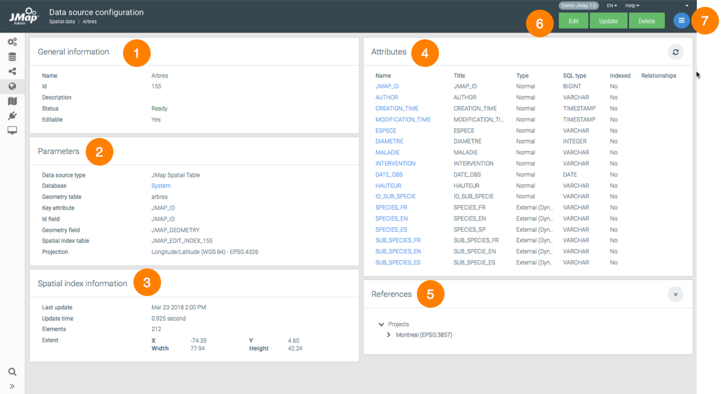
The spatial data source (SDS) configuration interface allows you to access information on a source as well as parameter configuration functions such as metadata, permissions, and attributes.

1 |
General information configured when creating the SDS. |
2 |
SDS parameters configured when it was created. The hyperlink allows you to access the DB that contains the data. |
3 |
Spatial information. The extent corresponds to the geographical extent of the elements contained in the SDS. When it has no elements, the values are equal to 0. |
4 |
Attributes. This section presents a list of SDS attributes. Clicking on the name of an attribute will open a window, allowing you to configure its properties. |
5 |
References. This section lists the projects and layers that use this SDS. |
6 |
These buttons allow you to edit, update or delete the SDS configuration. |
7 |
The menu provides access to the Metadata, Permissions and Schedule sections. |
The attribute configuration window contains two tabs: Metadata and Attribute sample. This button  is used to update the statistics of the SDS.
Metadata |
|
Type |
Indicates the attribute's data type. |
SQL Type |
Indicates the SQL type of the attribute data. |
Indexed |
Check this box to have the attribute indexed. |
Title |
You can change the title of the attribute. This icon |
Format pattern |
Specify a format pattern for displaying SDS items. The pattern must follow the Java standards. This article offers more details: https://docs.oracle.com/javase/tutorial/i18n/format/decimalFormat.html. |
Upon saving, recursively apply to associated layers... |
By checking the appropriate boxes, you will apply the title and/or format pattern of the attribute to all layers that are associated with the SDS. |
The Attribute sample tab displays the value of the attribute for a sample of SDS elements.
