Tracking allows you to define and manage levels of service for various types of operations, such as snow removal on streets, and to assign these levels to road network sections. For example, you could assign level 1 to the city's main roads, level 2 to main streets, and level 3 to less important streets. This offers a quick way to organize and track the progress of operations based on specific levels, which respect the priorities defined. You can also use activity reports to document the operations based on the levels.
To define service levels:
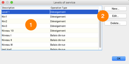
1.Click on Levels of service...  in the functions toolbar to display the Levels of service management interface.

1 |
List of levels defined, along with the type of operation associated with each one. |
2 |
These buttons allow you to create a new level, edit an existing level or delete a level. |
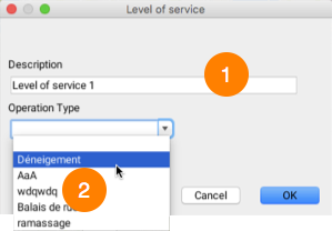
2.Click on New... to create a new service level. An interface displays, allowing you to define the level.

1 |
You must enter a name for the level. |
2 |
You can select the type of operation in the drop-down menu. The options have been defined by the JMap administrator. |
3.Click on OK to complete the configuration. The level you created is displayed in the list.
4.Click on Edit... to modify the level. The level's configuration interface displays. The options are the same as for step 2.
5.Click on Delete... to remove the selected level of service.
Once you have established levels of service for the various types of operations, you can associate road sections to the levels. To do this, you must have a layer with the road network's data.
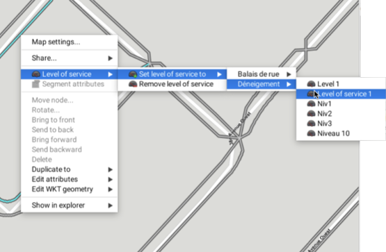
1.Select the road section(s) to which you want to associate the level of service.
2.Right-click to open the pop-up menu.
3.Open the following menu: Level of service -> Set service level to.
4.Select the type of operation and the desired level of service.

Using a report configured by the JMap administrator, you can view the progress of the operations in the road network, categorized according to the levels of service.