Introduction
Table of contents
Definitions and objectives
Info-RTU Web is a geomatic application that provides a map interface allowing users to view projects planned in the public right-of-way by different partners (MTQ, Bell, Énergir, CSEM, Hydro-Québec, boroughs, cities, etc.), share information on these projects, and find the contact persons for each project.
The goal of Info-RTU is to improve the coordination of projects planned between the different partners in order to minimize conflict situations.
This document is the Info-RTU Web User Guide. Its PDF version is available here.
Projects to add
The contact person is responsible for adding any project that requires excavation on public thoroughfares (streets and sidewalks), that causes an obstruction for more than one week or that is deemed likely to cause a major obstruction on the road network.
Examples of projects to add:
-
Road repair work (PRR);
-
Construction and rehabilitation of water, sewer and gas lines;
-
Reconstruction and rehabilitation of access wells;
-
Modifications and additions to the municipal underground network
Examples of projects that should not be added:
-
Small repair jobs requiring one to two days of effort;
-
Sidewalk slabs, rotary sawing of public utilities;
-
Fixing potholes;
-
Installing Bell or Hydro-Québec poles.
Graphical interface
Info-RTU Web’s graphical interface allows you to access all of the application’s functions. You can add your projects, view their information, and perform various searches in the projects that have been added.
The graphical interface contains a lateral bar with icons that allow you to access the tools and the map in which the projects are displayed.
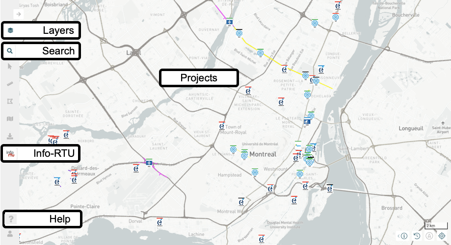
Layers
The Layers  panel displays a list of all the data layers in the application, which are organized into thematic groups. Each thematic group is displayed in a file, or card. Base maps are also available as map backgrounds.
The INFO-RTU group contains the Demandes d’intervention and Projets layers.
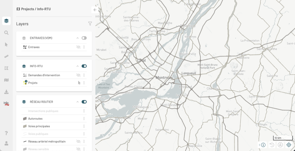
To display or hide a group of layers in the map, slide the toggle switch  to the right or to the left.
To display or hide a layer on the map, click on the  icon that displays when you hover the mouse pointer over the layer.
Some layers are displayed within a given interval of scales. Indeed, displaying a high volume of map elements on a small scale (i.e. when the map shows a large territory with little detail) can make it difficult to read the map effectively.
When layers are not displayed because of the scale, their name and symbol will appear in very light gray. When you change the map scale, these colors will darken, indicating that the layer appears in the map if its display is enabled.
To open or close the card of a group of layers, click on the ![]() or
or ![]() icons.
icons.
The Projects layer
This layer contains the projects that are currently underway. Each project is represented by an object, comprised of a set of symbols associated with the extent of the project (empreinte du projet) on the territory and the partner’s logotype. The latter is located at the project’s point of implementation. For details on this topic, see Positioning a project.
This layer displays a thematic based on the type of project. That is to say that different types of projects have a specific appearance. To display the legend of the thematic:
-
Click on the symbol of the Projects layer, located to the left of the name of the layer. The Thematic(s) panel displays. Each type of project is indicated with its symbol.
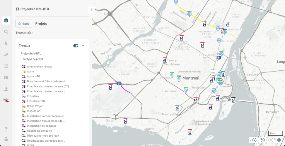
-
Click on Back to return to the Layers panel.
The Demandes d’intervention layer contains objects whose symbology represents work requests on the territory.
For detailed information on the features associated with layers, refer to the JMap NG User Manual.
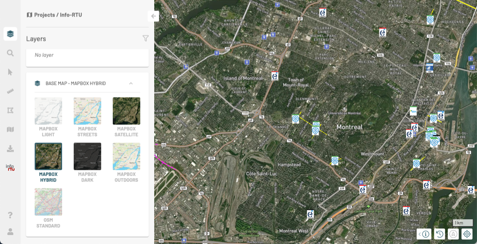
Base maps
The BASE MAP card contains layers called base maps. These offer a context to display the layers’ data. Base maps are provided by Web map servers such as Mapbox and OpenStreetMap. You can only display one base map at a time.
-
Click on the thumbnail of the base map you are interested in to select it. The map automatically displays. The name of the map is displayed in the header of the card.
Searches
The Search  panel displays the searches you can launch to identify elements that meet different criteria.
The Finding a location section displays the available queries, allowing you to locate a project in the territory based on different criteria.
Info-RTU
The  Info-RTU panel contains three sections:
  Filters,
  Projects and
  Contacts.
The Filters section displays the available filters that allow you to view only the projects you are interested in based on several criteria. The Filtering Projects section provides details on how to use filters.
The Projects section shows the projects added in the application. When you apply a filter, the projects that meet the filter’s criteria are displayed in the map and in this panel. For detailed steps on how to work with projects at different stages of their life cycles, see the following sections: Viewing Projects, Creating a New Project, Editing Projects, Deleting a Project and Importing and Exporting a Set of Projects.
The Contacts section allows you to identify the contact persons of the partners based on a location on the territory. For details on this feature, see Searching for Partner Contacts.
Help
The help  section contains links to the Info-RTU User Guide, the JMap NG User Manual and the JMap NG Developer Documentation.